River Des Peres near Manchester Road. Photograph by John W. Dunn, ca. 1890. Missouri History Museum Photographs and Prints Collections. NS 28040. Scan. Ⓒ by Missouri History Museum, All rights reserved. Used by permission.

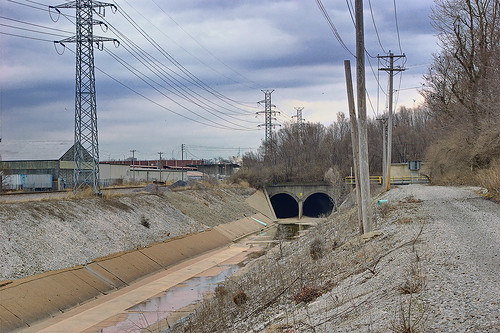
River des Peres near the intersection of Manchester and Macklind Avenues, in Saint Louis, Missouri. Photo taken February 26, 2009.
As these photos show, the River des Peres in Saint Louis, Missouri, was once a natural stream and now is largely placed in a channel, with significant parts of it flowing through tunnels.
As with many watercourses in the old colonial territories of Louisiana and Canada, this stream's name is French: la Rivière des Pères, meaning River (or Creek) of the Fathers. The ‘fathers’ in the name were the Jesuit priests Pierre-Gabriel Marest and Jacques Gravier, who founded a mission to the Kaskaskia Indians at the mouth of this stream.
There has been recent work to beautify the lower sections of the river. Due to silting of the lower channel, that section of the river now has enough perpetual flow to allow canoeing. As far as I know, this has yet to be done, but I'd like to try it this summer!


Wow! You found a time machine there? I notice you retrieved the second picture from one month into the future ;-)
ReplyDeleteI like what's been done in some sections of the 'river,' but it needs a lot of work before people will be able to appreciate it again.
Ooops. I corrected the date. Thanks!
ReplyDeleteI think the appearance of silting is actually a result of the River des Peres Beautification Project, isn't it? And the canoeing sounds brave - flow is still received from combined sewer overflows upstream, so you might run into some 'undesirables.'
ReplyDeleteMaybe they are doing more filling-in of the channel, but silting has been going on all of my life, with the vegetated area expanding in width and depth.
ReplyDeleteI am a bit worried about the combined sewers, but had the impression that this only occurs during severe rain run-off.